General Discussion
Related: Editorials & Other Articles, Issue Forums, Alliance Forums, Region ForumsIn deadly Texas floods, one town had what some didn't: A wailing warning siren
As heavy rain triggered flash flood warnings along the Guadalupe River in Texas Hill Country early Friday, the small unincorporated town of Comfort had something its neighbors upriver in Kerr County didn’t: wailing sirens urging residents to flee before the water could swallow them.
Comfort had recently updated its disaster alert system, installing a new siren in the volunteer fire department’s headquarters and moving the old one to a low-lying area of town along Cypress Creek, a tributary of the Guadalupe that is prone to flooding. Friday was the first time the new two-siren system had been used outside of tests, providing a last-minute alarm for anyone who hadn’t responded to previous warnings on their cellphones or evacuation announcements from firefighters driving around town.
“People knew that if they heard the siren, they gotta get out,” said Danny Morales, assistant chief of the Comfort Volunteer Fire Department.
Morales said that no one died in Comfort, a town of about 2,300 people in Kendall County. But in Kerr County about 20 miles away, dozens of people, including young girls staying at Camp Mystic, a riverside Christian summer camp, were washed away when the Guadalupe surged over its banks and swamped the surrounding countryside. As of Monday evening, officials said, 104 people had been confirmed dead, 84 of them in Kerr County, including dozens of children. Kerr County has no siren system despite years of debate, in part because some local officials felt it was too expensive to install.
https://www.yahoo.com/news/deadly-texas-floods-one-town-001729029.html
I read another article where it was said people in the area were averse to any kind of tax increase.
 = new reply since forum marked as read
Highlight:
NoneDon't highlight anything
5 newestHighlight 5 most recent replies
= new reply since forum marked as read
Highlight:
NoneDon't highlight anything
5 newestHighlight 5 most recent replies

DBoon
(23,981 posts)and because they would rather own the libs by turning down Federal funds from the Biden administration
https://www.democraticunderground.com/100220468310

mwmisses4289
(1,564 posts)
Old Crank
(5,930 posts)A friend is a lawyer in Texas, she says it will be unlikely for jurisdictions to be sued. She says sovereign immunity for these actions or nonactions.

John1956PA
(4,303 posts)Political and Economic Analysis
In modern times, the idiom is often used in political and economic commentary to describe actions by a political actor, party, corporation or nation that appear (at least to some) to damage the actor's own interests in pursuit of harming an adversary.
Examples of events the phrase has been used to describe include the tariff policies of the second Trump administration . . .
https://en.wikipedia.org/wiki/Cutting_off_one%27s_nose_to_spite_one%27s_face

barbtries
(30,602 posts)republicans in the town didn't want to pay for it.

efhmc
(15,724 posts)Why can't these be upgraded and used?

LeftInTX
(32,811 posts)San Antonio does not have sirens. Kendall County (one county over) installed them in response to flooding
I doubt if Kerrville has tornado sirens.

pinkstarburst
(1,785 posts)Austin stated that they are cost prohibitive to install and maintain (and think of how much money a city the size of Austin with that sort of high tech tax base has compared to somewhere like Kerrville), and that they only really work if you are outside and can hear them.
They said their focus is on warnings systems that use advancing updated tech--cell phone warnings.

cadoman
(1,495 posts)You'd think a city like fucking $AUSTIN$ could afford that??
Old Crank
(5,930 posts)Installation, maintenance, informing populace, testing etc.
cadoman
(1,495 posts)And it's measured in the thousands to low millions.
pinkstarburst
(1,785 posts)https://www.kxan.com/investigations/kerrville-didnt-have-weather-sirens-used-by-other-cities/#:~:text=Austin%20doesn't%20have%20a,sirens%20could%20%E2%80%9Ccause%20confusion.%E2%80%9D
https://www.kxan.com/news/local/why-didnt-the-tornado-sirens-go-off-in-the-austin-area-during-mondays-tornado-warning/

summer_in_TX
(3,699 posts)Depending on topography, they may have little need for tornado warnings. It sounds like they don't have them.
pinkstarburst
(1,785 posts)When asked why, Austin officials cited that it was cost-prohibitive to install and maintain them, that they had to be constantly tested, and that they were only really effective for warning people who happen to be outside at the time.
They stated that it was much better to use the technology we have in place--alerts that go out over phones.
efhmc
(15,724 posts)They did when I lived there because I freaked out when I first heard it. It was an air raid siren.
gab13by13
(28,890 posts)if our Volunteer Fire department needs a new engine we do a fund drive.
Back in the 60's we partnered with the Army Corps of Engineers that built our flood protection dykes for the stream that flows through the middle of our town, our town has not flooded since.
You get what you pay for.

surfered
(8,014 posts)Yo_Mama_Been_Loggin
(126,169 posts)I live on the west coast and I've seen them.
Trailrider1951
(3,529 posts)There is one right down the road from me, which they test every first Monday of the month. I used to live in the Texas hill country NW of Austin. The reason those folks don't have warning sirens is because stupid republicans don't want to pay for them.
gopiscrap
(24,430 posts)I live in Tacoma and have head those sirens. Also when in school in Tacoma every Wednesday they would test the emergency siren agt 230 I used to loe that because I knew when it went off there was only a half hour of school left

spanone
(139,665 posts)
Attilatheblond
(6,721 posts)Great-great aunt maintained the view that "you pay for what you need, whether you buy it or not".
So sad that children had to pay with their lives for a decision they didn't get to vote on.
moondust
(20,949 posts)Patrick added, "Had we had sirens around this area, up and down -- the same type of sirens they have in Israel when there's an attack coming, that would have blown very loudly -- it's possible that would have saved some of these lives."
~
https://abcnews.go.com/US/hard-hit-texas-county-flood-warning-sirens-despite/story?id=123531823

rampartd
(2,214 posts)kids these days don't know what they missed.
flashman13
(1,407 posts)waterwatcher123
(384 posts)Most every dam in the country has a warning light attached to it to make sure that the pool height is at or below the design capacity. Otherwise, a spillway or sluice gate could easily fail, and no one would know until the water started to flood adjacent areas. These lights could easily be adapted to a USGS gauge where lights and/or sirens could immediately activate at bank-full to warn vulnerable places (the lights and siren can be located remotely from the gauge). USGS also has a warning system like the NWS for most of their streamflow monitoring sites. However, it does not look like they have the authority to use the wireless emergency alert system. This authority should be changed since USGS and states run most streamflow monitoring stations.
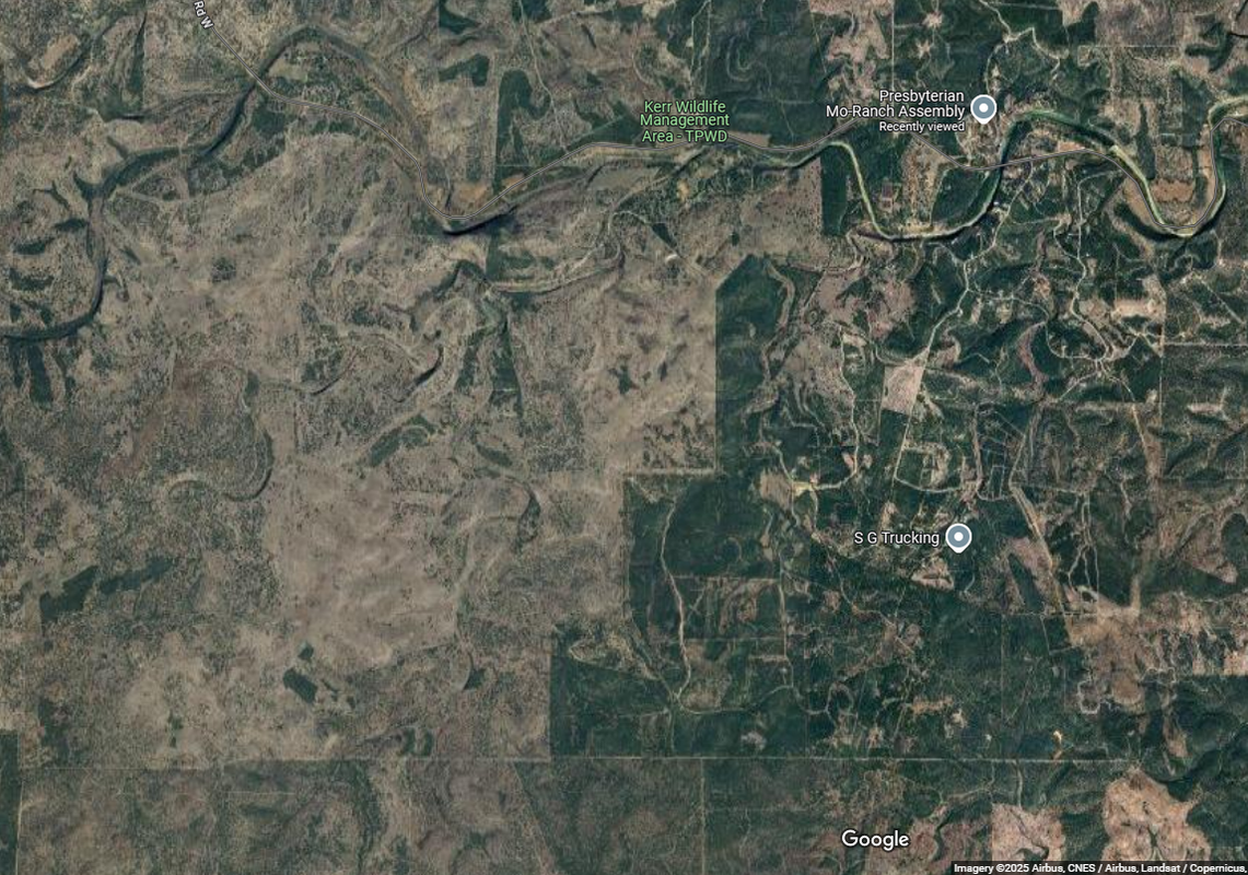
It appears from looking at the satellite imagery of the upper Guadalupe River that extraordinarily little effort has been invested in keeping the upland areas forested. Forests are critical to the storage of water for lots of reasons (trees intercept rainfall, root systems help with infiltration, forest animals who dig provide storage in tunnels and underground homes, and so on). Forests are also typically associated with wetlands and landscapes dotted with wood and landscape depressions). Many of these water holding features are completely absent in pastureland and/or cleared areas. There also appear to be big sections of the river where there is little forest canopy even adjacent to the stream (critical areas for aquatic ecology). Forests cannot stop a huge storm event from producing catastrophic flood conditions. But forests are critical to delaying water that would otherwise be delivered rapidly to river's main channel. The flood hydrograph of the upper Guadalupe mirrors that of a highly developed urban watershed (rapid rise, rapid fall). So, there needs to be a lot more attention devoted to keeping the water on the land. Even allowing beavers to restore the water storage capacity of the upper Guadalupe River would be a good place to start.
LeftInTX
(32,811 posts)The trees huddle along the banks of river. Bald cypress is a beautiful aquatic tree, which is preserved in the area. However, if you try to grow bald cypress several hundred yards from water it won't survive. Away from water there are junipers, mountain laurels, mesquite, and oaks.
Closer to water and in irrigated areas, there are cedar elm and hackberry.
Oak wilt is killing our oaks. It is devastating. There isn't much that can be done, except using expensive chemicals. Maybe you saw devastating oak wilt centers?
The area that was hit hardest (children's camps) is undeveloped. The torrents that killed the campers began in an undeveloped area. They didn't begin in Kerrville.
They began up in this area here. The area west of Kerrville is transitions to semi-arid.
waterwatcher123
(384 posts)The point I was trying to make is that forests are critical to water storage. So, to the extent that forests can be re-established on the upland, it will help a great deal in slowing runoff from reaching the main stem of the river. It is especially true in areas with considerable elevation change from the river channel to upland areas. You know the tree canopy better than anyone who is less familiar with the region. So, I assume there are groups working to replace trees lost to oak wilt? Any variety of tree canopy is better than no canopy. There is a great free tool produced by the Davey Tree Company and NY University to help communities design and plan replanting efforts. If you are interested, it is called I-Tree Canopy (https://canopy.itreetools.org/). I saw that Texas is engaged in trying to bring beaver back to the state too. This is a good idea as beaver are incredible when it comes to storing water and restoring streams (although they do impede recreation to some degree - fish passage not as much as originally thought).
It is terrible what happened to everyone and the kids at Camp Mystic. But, as someone who has studied rivers and watersheds for years, what occurred to me is that camp is situated in an extremely dangerous place for floods. It is on the inside of a large meander with a bedrock wall on the left bank. There is little to no floodplain on the left side of the river. As such, once the river over tops its bank and floods, all the water would be directed right at Camp Mystic and Cyprus Creek. This river would cut right through this meander naturally if allowed to pursue its own course. Rivers do this all the time and form oxbow lakes and riverine islands.
My apologies if the post sounded insensitive. This is a tragedy that might have been minimized to some extent with more emphasis on keeping water on the land (forests, depressions, wetlands, and wild lands). This was a huge storm event that would have had a serious impact regardless of the mitigation efforts. We had a similar event in 2012 in our area that dumped 8-10 inches of rain on the land in a 24-hour period (there were periods of extreme rainfall intensity too). What I noticed in walking/photo documenting the streams is that areas with forests survived better than non-forested regions. What you also see is that humans do all sorts of foolish things with streams (like building personal dams, diverting parts of the stream channel, installing their own drainage systems that dump into the river and building in the floodplain. I even had a picture of a house where the homeowner used a culvert to run the small creek right under their house (condemned by local authorities).
I hope they do find all these missing people. However, it is highly likely that some of these people will never be found. Rivers can move unimaginable amounts of sediment, gravel, and boulders. I have struggled to find monitoring equipment buried by sediment after a typical storm event. This event is so large that finding someone buried by feet of sediment or gravel will be a herculean task.
LeftInTX
(32,811 posts)That's because wildfires controlled vegetation before it was settled.
There is no industry in the area. The soil is so rocky that crops can't be grown. Angora goats are the most common livestock.
Here is natural vegetation at the headwaters of the Guadalupe River. Notice that trees literally grow out of rocks. Notice there is no soil. Seeds drop in cracks and and sometimes it takes years for plants to germinate. It doesn't rain very much over here! It's semi-arid.
Below these rocks are caves with water.
The junipers slow water runoff.
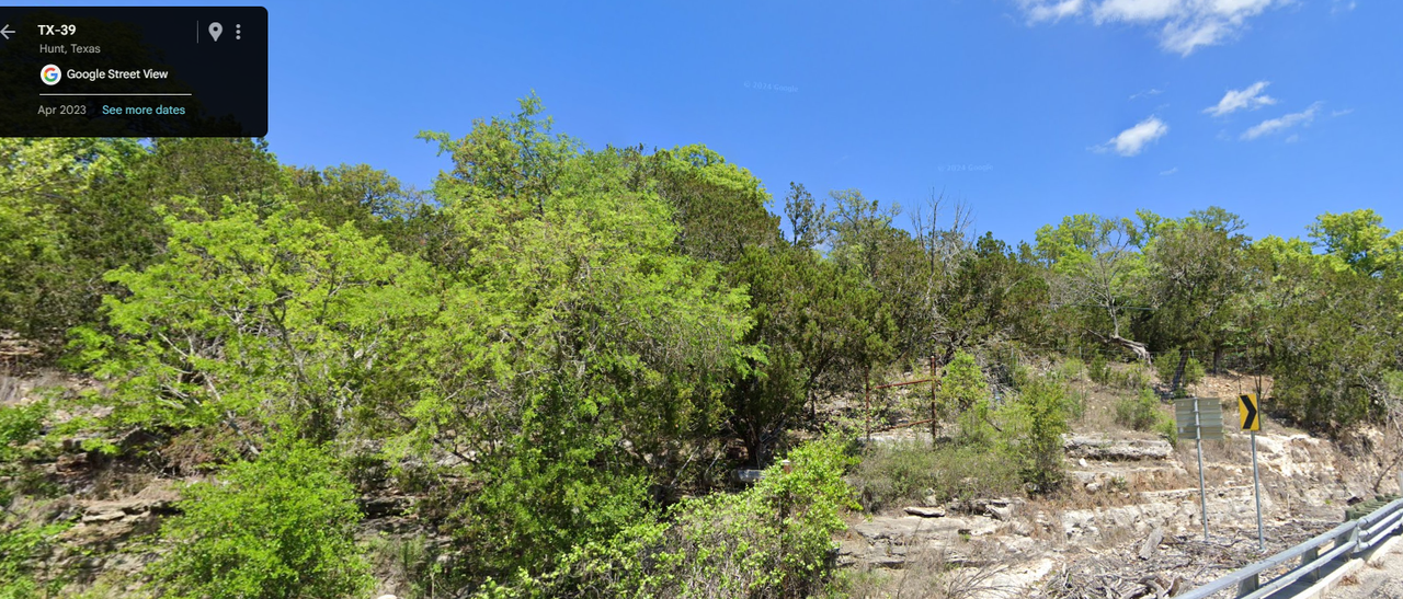
Here is vegetation on the Guadalupe River at the city park in downtown Kerrville
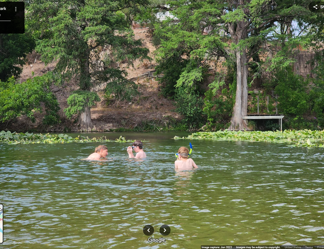
Notice the beautiful bald cypress. The cypress trees do moderate the flows. Cypress only grow in the water.
Our rivers and water are sacred! These towns basically exist as resorts.
There are beavers in the area, but their populations are low. They have never been hunted for fur in this part of Texas.
East Texas, is an entirely different ecosystem. If you look at maps of East Texas, you will see lush vegetation. Yet that is a timber producing area and it gets about 60 inches of rain per year. There is lot of industry in East Texas too. It all has to do with the amount of rain. So, lush doesn't tell the whole story!
I agree that Camp Mystic is in a terrible place with regards to flooding. It's between a creek and the river and it appears much of it literally in an old river bank. (Maybe built on a gravel bar). It also appears to have a dry creek coming from the top of the hill. (arroyo) If you built prior to flood zoning, your structures can stay. Camp Mystic has been around since 1926. Also, FEMA allows "cabins", "temporary structures" in flood plains.
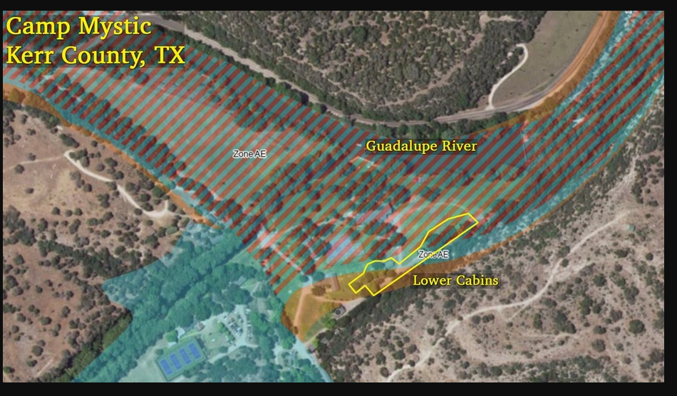
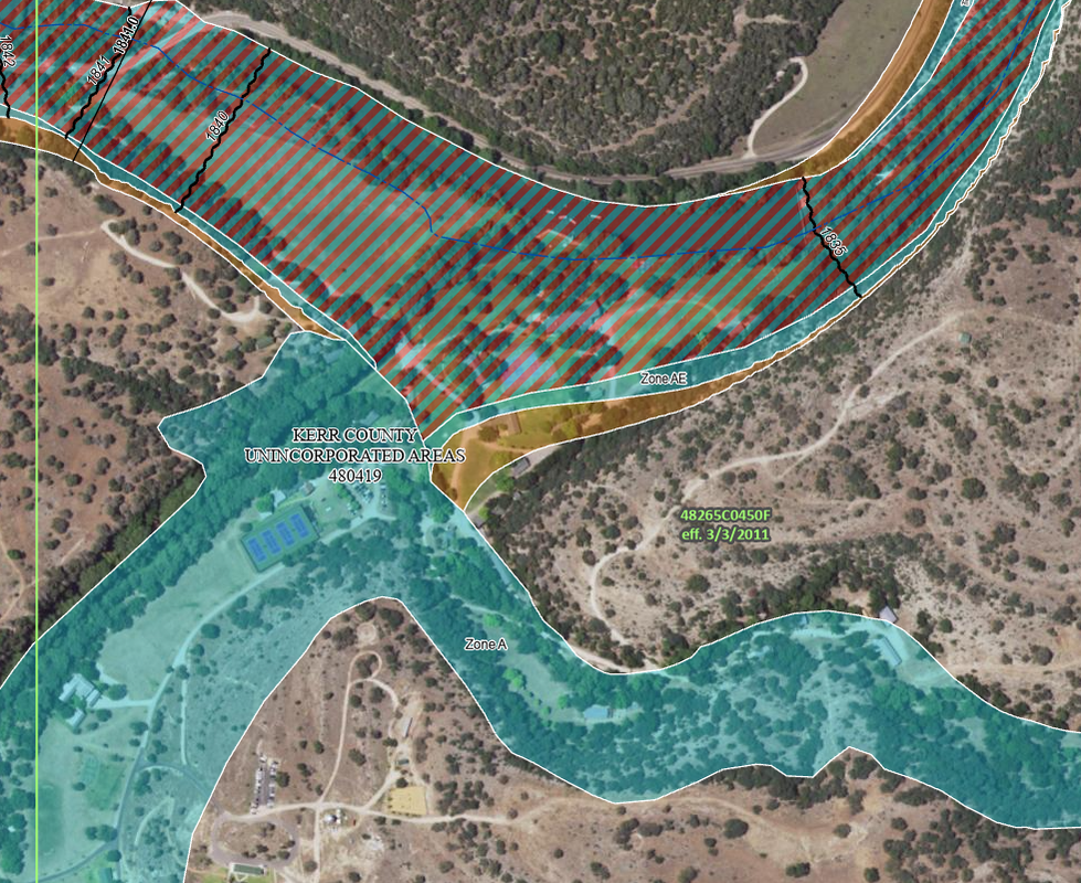
Map Shows Texas Girls’ Camp Where Dozens Drowned Was Located in High-Risk Flood Zone (Caveat: Many campgrounds in parks, state and national are in food zones!. Plop your tent next to a lake. You are taking a risk. You are generally responsible for monitoring the weather)
https://www.realtor.com/news/real-estate-news/map-texas-girls-camp-mystic-flood-zone/
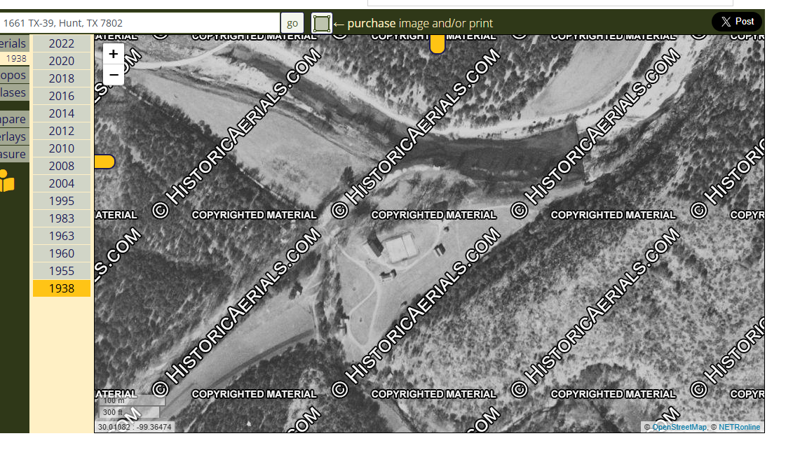
Here is the oldest aerial of Camp Mystic that I can find. It's from 1938. There also seems to be a drainage channel from the top of the hill. It may look benign when dry, but those areas can turn into torrents.
waterwatcher123
(384 posts)You know the soil characteristics and tree canopy of the area better than anyone looking at imagery. However, there were some areas where the tree canopy abruptly ends at right angles, which makes it appear cleared. How do local authorities and landowners suppress wildfire without cutting the vegetation? It must be incredibly hard to fight fires in this rugged and dry terrain (does not appear like there many available surface water sources to fight fires other than the Guadalupe itself).
Is it the porous limestone and high rates of evaporation that account for the extremely dry landscape? I looked at a few maps of average annual precipitation for Texas. Austin and San Antonio averaged around 30-33 inches per year (which is enough to support trees elsewhere). Does the upper Guadalupe River have a similar precipitation regime? If so, it must be something other than precipitation that is the limiting factor for trees.
Camp Mystic did look like it was situated right on a fluvial feature. It is too bad that FEMA does not re-assess these grandfathered in properties built in floodplains. A cabin is not really a temporary structure even though it might be occupied intermittently. I tried to find the zoning code for the county on their website. But it sounds like the county does not do enforce zoning codes outside of incorporated areas. They must have some code requirements otherwise it would be impossible to enforce the floodplain requirements (maybe in building permits?). The county could have easily required these at-risk properties to install their own warning systems if they wanted to error on the side of caution. A simple float switch tethered to a post near the riverbank could trigger a warning siren and lights (no guarantee it would have saved everyone - but at least there would have been a greater chance).
Again, thanks for your patience in explaining what is so unique about this river system. The upper Gaudalupe River is obviously a highly valued recreational resource (otherwise it would not have so many camps and campers). It was alignment of circumstances that led to this regrettable outcome (huge storm event, middle of the night, lots of people in flood prone areas, 4th of July holiday). Hopefully, there will be some lessons learned that be applied to prevent a repeat scenario. Maybe the Guadalupe River Authority can start to be more active in trying to encourage changes in floodplain management and encourage efforts to infiltrate and keep water on the land. It is nice to hear beavers are playing a role too. It took this country years to recognize how important they are to watershed management and stream ecology (the Europeans and their beaver hats were a big part of the problem).
I wish you and your neighbors the best as you recover from this tragedy that claimed so many lives and altered a natural resource you clearly value.

Hassin Bin Sober
(27,159 posts)Gimpyknee
(370 posts)What a novel idea.
Jirel
(2,351 posts)I’m from the flood area that this article is talking about. As I mentioned in my own comment, the sirens were useful as legs on a snake. They blew AFTER people were out, or trapped. Comfort’s many types of warnings worked well, but sirens were the pro-forma afterthought, like blowing a tornado siren when the tornado is already cutting a path through town.
Now let’s talk about whether they would’ve mattered upstream. The answer is probably not. Out-of-towners imagine Hunt, Ingram, Kerrville, Center Point, and Comfort as small towns on a river, pretty close together. Nope. It’s more like a 50+ mile stretch of Guadalupe with MANY SECONDARY CREEKS that can be as nasty for flooding, even though many are dryish this year with the drought. The hardest hit people are nowhere near the towns, but on much less populated stretches in between. Many of those areas only get a lot of visitors seasonally in camps or RV parks, the closer to Hunt you go.
As for sirens, they are not designed to be heard everywhere, indoors. They are meant to be heard outdoors. That’s not where people were in the pre-dawn hours.
There are many more useful things you could do to improve safety, first and foremost through regulation and education. What works best indoors? Weather alert radios. A drive to supply residents and camps with those, and education about using them, would have been far more effective than sirens. They would’ve gone off MUCH earlier, for one. NOAA had warnings out before 2 am. The radios are not tied to politicians’ decisions on when to blow them, or different cities’ emergency protocols. Sirens are. Weather emergency radios explain what’s happening. Sirens just go off, and are ignored just like the annoying car alarms on a city street.
Additionally, a lot of the area has few zoning codes. Most of it is on unincorporated land. If you look at the large RV resort that got washed away, your jaw will drop. It’s a giant area of tightly packed RV slots, tent sites, and cabins, right there on the river bank on low ground, with one main (tight) road in and out. Evacuation itself would be difficult. Same with these camps. Camp Mystic was in a dangerous area that had flooded before, with no safe access out during a flood, yet they still hadn’t spent the money on safety planning and equipment in a hundred years of operation. They were locked in before sirens would’ve sounded for the river flood. These private operators are allowed to do more or less what they want. At minimum, there should be a requirement for businesses that host people on the banks to use weather radios for monitoring, and to have a safety plan for how they will evacuate their guests. Sirens wouldn’t have helped - 750 campers or hundreds of RV park guests all trying to get out in the relatively short time after a siren goes off would be disaster. If the operators had the warning HOURS ahead from a weather system (assuming they took it seriously), that could’ve saved most of those lives.

Sogo
(6,474 posts)I'm in tornado country.....We take it seriously.
Every Wednesday at Noon.
I know nothing of the geographic area involved, but there is a good chance that covering the entire “at risk” population just isn’t feasible.
In hindsight sight, flash flooding (and the accompanying mudslides) are what killed a lot of people in North Carolina as well.
We had our own disaster recently but in light of Texas, it was not nearly as bad.
Jirel
(2,351 posts)I. Live. In. Comfort.
By. The. Guadalupe. And. Cypress. Creek.
This out-of-town reporter is so full of crap, their eyes are brown.
Fact: nobody here was saved by the sirens because we all had LOTS of warning from multiple sources long before sirens went off. Comfort residents take floods seriously because we’ve had a lot, including some infamous ones with deaths (the most recent one has a memorial built just up my street where she died), and we watch the weather, NOAA and USGS water gauges, etc. Everyone was glued to town gossip as well, in part because the 4th of July parade had been canceled. (Fun fact: the lineup area was right in the lowest area by the river.) The VFD and other first responders had door-knocked house to house well before that. Sheriffs, constables, etc. were all over the streets blaring warnings over their loudspeakers long before the sirens went. By that time, everyone was out of their homes. If anyone had waited until the sirens blew, they would’ve been in deep water, too late. Water had covered the escape route for homes along the river road an hour before that - we were monitoring the creek flow, and friends were in a big truck monitoring that area and had taken video of the highway in the process of being covered (not yet deep, but the road to it was) that early on.
Fact: Comfort is a HUGELY different situation than Kerrville, Hunt, or Ingram. We’re a small town 1/10 the size of Kerrville. Simply fewer people to flood. We don’t make bank off the tourist trade with RV parks, cabins, and camps on the water’s edge. So the most vulnerable people who don’t know the flooding situation and are not taking it seriously, weren’t here in town to make a fatal error. We did have flooding in one RV resort, but even that one is much farther away from water and much smaller than the behemoth in Kerrville where many died.
Fact: While Hunt had about 3 hours warning but it was the middle of the night (gotta be awake and willing to respond to warnings at o-dark-early for them to matter), Comfort had effectively 8 hours warning, and we were all already well aware of what had happened upriver for hours before we were smacked.
This is out-of-towner armchair quarterbacking at its finest.
Buddyzbuddy
(1,200 posts)This isn't in hindsight. This is preparing for the worst and hoping for the best.
Here in California, earthquakes are unpredictable and unpreventable but we prepare for the inevitability. Our government requires homes to be built to code, older buildings must be retrofitted. That's what preparedness looks like, based upon scientific studies and history.
Floods happen but warnings are absolutely available if you don't ignore the science and provide the resources for the inevitable.
These tragedies were preventable, maybe not all, but most. This was a man made mistake, not "God's" fault as f.cking Ted Cruz would have you believe. Whatever you do, don't blame any Republicans.
Texas should have a warning sign at all entry points "Now entering Texas, a state run by Republicans for Republicans, enter at your own risk"
I'm sorry to all of our Democratic population in Texas but your presence is needed there if we're to have any chance of replacing the insane with sanity. I'm also sorry for those that lost their lives so unnecessarily.
brush
(60,620 posts)Last edited Tue Jul 8, 2025, 06:04 PM - Edit history (1)
should be held accountable come the midterms.
Also work with the cell tower people to get good signals ther...all three recommendations were from Gen. Russell Honore who has become to go-to guy to consult in natural disaster occurrences since his excellent how-to demonstration when he took charge of the Katrina hurricane evacuation in Louisiana years back.
pinkstarburst
(1,785 posts)This area is unique because it has so many recreational spots, lots of out of towners who may be unfamiliar with the dangers posed by the river and may be unfamiliar with escape routes. It also has bad cell phone reception.
The best thing is for people to have NOAA weather radios and pay attention to weather alerts on their cell phones. But let's face it, most people are not good at preparedness. And if cell phone coverage is spotty, or if the camp directors don't allow counselors and children to have cell phones (and may not be monitoring the weather themselves), then having redundancies in place might save some lives should this happen again.
Would the sirens help in the event a flood like this were to happen again during the daytime when people were awake and outdoors? Probably. It would give people time to get to high ground.
Would the sirens help in the exact scenario we saw over the 4th of July flooding, where it was the middle of the night, the victims were all indoors and asleep, and might not hear the sirens? Not necessarily, unless you were right on top of a siren. The sirens are designed to be heard outdoors. If you are a mile away from the closest one and indoors AND awake, maybe you still hear it? If you are asleep in the middle of the night... I still worry the outcome would have been the same. But I agree it would probably be good to put them in since this is such a popular area and they could potentially save more people. This was such a horrible "perfect storm" type tragedy. In addition to putting the sirens in, they should create legislation changing camp regulations to require NOAA weather radios and camp directors to monitor them when warnings are issued in the area.