Welcome to DU!
The truly grassroots left-of-center political community where regular people, not algorithms, drive the discussions and set the standards.
Join the community:
Create a free account
Support DU (and get rid of ads!):
Become a Star Member
Latest Breaking News
Editorials & Other Articles
General Discussion
The DU Lounge
All Forums
Issue Forums
Culture Forums
Alliance Forums
Region Forums
Support Forums
Help & Search
Environment & Energy
Related: About this forumAnother El Nino Already? What Can We Learn from It? -- James Hansen, et al.
https://www.columbia.edu/~jeh1/mailings/2026/ElNino.2026.02.06.pdf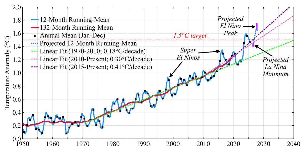
Fig. 1. Global surface temperature (relative to 1880-1920 base period).¹
Another El Nino Already? What Can We Learn from It?
06 February 2026
James Hansen, Pushker Kharecha, Dylan Morgan and Jasen Vest
Abstract. The world seems headed into another El Nino, just 3 years after the last one. Such quick return normally would imply, at most, an El Nino of moderate strength, but we suggest that even a moderately strong El Nino may yield record global temperature already in 2026 and still greater temperature in 2027. The extreme warming will be a result mainly of high climate sensitivity and a recent increase of the net global climate forcing, not the result of an exceptional El Nino, per se. We find that the principal drive for global warming acceleration began in about 2015, which implies that 2°C global warming is likely to be reached in the 2030s, not at midcentury.
It is important to understand ongoing global temperature change as well and as soon as possible for the sake of policy assessment. As a first step for discussion, let us clarify what is shown by the blue curve in Fig. 1: it is the 12-month running-mean of the global temperature anomaly relative to base period 1880-1920 (the earliest time with data adequate for a reliable multi-decade global mean). Black squares in the blue curve indicate the annual mean (Jan-Dec) temperature.
Researchers often show annual temperatures connected by straight lines, as in Fig. 2.² If the blue curve in Fig. 1 is replaced by straight lines connecting the black squares, our graph becomes Fig. 2. We prefer³ the 12-month running-mean, which takes out noise and seasonality of temperature change at any time of year; no need to wait until December. The higher temporal resolution of the running-mean provides more information, e.g., in studying the global temperature response to a volcano, which may occur in any month with a climate effect of limited duration.
El Nino. The El Nino/La Nina cycle is the main cause of global temperature oscillation in Fig.1. During the more persistent La Nina phase, easterly (east-to-west) trade winds in the equatorial Pacific push warm surface water toward the western Pacific, causing upwelling of cold deepwater near South America. Atmospheric circulation engendered by this ocean temperature
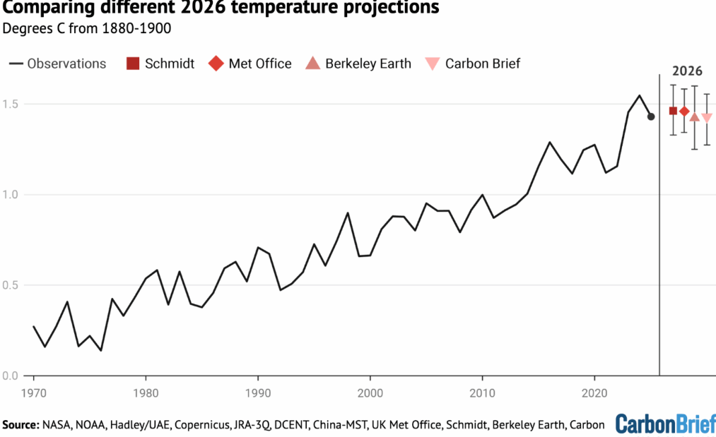
Fig. 2. Multi-analysis-mean global temperature for 1970-2025 and projections for 2026.
pattern reinforces the trade winds and helps perpetuate the temperature pattern (UK Met Office video). This reinforcement (Bjerknes feedback) can temporarily work in the opposite sense and spur an El Nino, if westerly wind bursts cause sufficient eastward movement of warm water. However, many factors including the initial ocean state, the phase of natural (Madden-Julian) atmospheric disturbances, the fickle wind bursts, even salinity anomalies in surface waters,⁴ make the occurrence and magnitude of El Ninos difficult to predict.⁵ ⁶
…

6 replies
 = new reply since forum marked as read
Highlight:
NoneDon't highlight anything
5 newestHighlight 5 most recent replies
= new reply since forum marked as read
Highlight:
NoneDon't highlight anything
5 newestHighlight 5 most recent replies
= new reply since forum marked as read
Highlight:
NoneDon't highlight anything
5 newestHighlight 5 most recent replies
Another El Nino Already? What Can We Learn from It? -- James Hansen, et al. (Original Post)
OKIsItJustMe
Friday
OP

BumRushDaShow
(167,253 posts)1. The past 4 or so years
we have been in a La Nina and/or Neutral ENSO. It's been awhile since we had an El Nino.

OKIsItJustMe
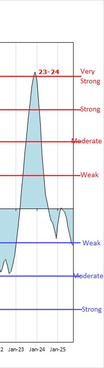
(21,725 posts)2. 2023-2024 El Nino event
BumRushDaShow
(167,253 posts)3. ...
We are in a La Nina right now - https://www.cpc.ncep.noaa.gov/products/analysis_monitoring/enso_advisory/ensodisc.shtml
It's a 56-year hobby.
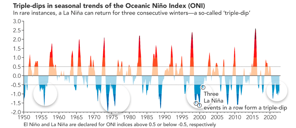
The El Nino state has been transitory recently and we have generally slammed back into La Nina and/or Neutral for whatever reason (climate change), including a "triple dip" La Nina a couple years ago - Understanding the driving mechanisms behind triple-dip La Niñas: insights from the prediction perspective
OKIsItJustMe
(21,725 posts)4. NOAA declares the arrival of El Nino
https://www.weather.gov/news/230706-ElNino
https://ggweather.com/enso/oni.htm

Expected to be moderate-to-strong by late fall/early winter
June 8, 2023 - The expected El Niño has emerged, according to scientists at NOAA’s Climate Prediction Center, a division of the National Weather Service. In the monthly outlook released today, forecasters issued an El Niño Advisory, noting that El Niño conditions are present and are expected to gradually strengthen into the winter.
El Niño is a natural climate phenomenon marked by warmer-than-average sea surface temperatures in the central and eastern Pacific Ocean near the equator, which occurs on average every 2-7 years. El Niño’s impacts on the climate extend far beyond the Pacific Ocean.
"Depending on its strength, El Niño can cause a range of impacts, such as increasing the risk of heavy rainfall and droughts in certain locations around the world," said Michelle L'Heureux, climate scientist at the Climate Prediction Center. "Climate change can exacerbate or mitigate certain impacts related to El Niño. For example, El Niño could lead to new records for temperatures, particularly in areas that already experience above-average temperatures during El Niño.”
El Niño’s influence on the U.S. is weak during the summer and more pronounced starting in the late fall through spring. By winter, there is an 84% chance of greater than a moderate strength El Niño, and a 56% chance of a strong El Niño developing. Typically, moderate to strong El Niño conditions during the fall and winter result in wetter-than-average conditions from southern California to along the Gulf Coast and drier-than-average conditions in the Pacific Northwest and Ohio Valley. El Niño winters also bring better chances for warmer-than-average temperatures across the northern tier of the country.
…
https://ggweather.com/enso/oni.htm
BumRushDaShow
(167,253 posts)5. Like I said, it's been "transitory"
Most of the rest of the recent years have been La Nina, about to go into ENSO Neutral.
I included a link to NOAA's CURRENT (2026) Advisory -
EL NIÑO/SOUTHERN OSCILLATION (ENSO)
DIAGNOSTIC DISCUSSION
issued by
CLIMATE PREDICTION CENTER/NCEP/NWS
8 January 2026
ENSO Alert System Status: La Niña Advisory
Synopsis: La Niña persists, followed by a 75% chance of a transition to ENSO-neutral during January-March 2026. ENSO-neutral is likely through at least Northern Hemisphere late spring 2026.
In December 2025, La Niña was reflected in the continuation of below-average sea surface temperatures (SSTs) across the east-central and eastern equatorial Pacific Ocean [Fig. 1]. The latest weekly Niño-3.4 index value was -0.5°C, with the Niño-3 and Niño-1+2 indices remaining cooler at -0.8°C and -0.7°C, respectively [Fig. 2]. The equatorial subsurface temperature index (average from 180°-100°W) became slightly positive [Fig. 3], reflecting the expansion of above-average temperatures from the western to the east-central Pacific at depth [Fig. 4]. Atmospheric anomalies across the tropical Pacific Ocean remained consistent with La Niña. For most of the month, easterly wind anomalies were present over the central equatorial Pacific, and upper-level westerly wind anomalies continued across the equatorial Pacific. Enhanced convection persisted over Indonesia and suppressed convection strengthened near the Date Line [Fig. 5]. The equatorial Southern Oscillation index was positive. Collectively, the coupled ocean-atmosphere system remains consistent with La Niña.
The IRI multi-model predictions indicate ENSO-neutral will emerge during January-March (JFM) 2026 [Fig. 6]. In conjunction with the North American Multi-Model Ensemble, the team favors ENSO-neutral to develop during JFM 2026. Even after equatorial Pacific SSTs transition to ENSO-neutral, La Niña may still have some lingering influence through the early Northern Hemisphere spring 2026 (e.g., CPC's seasonal outlooks). For longer forecast horizons, there are growing chances of El Niño, though there remains uncertainty given the lower accuracy of model forecasts through the spring. In summary, La Niña persists, followed by a 75% chance of a transition to ENSO-neutral during January-March 2026. ENSO-neutral is likely through at least Northern Hemisphere late spring 2026 [Fig. 7].
This discussion is a consolidated effort of the National Oceanic and Atmospheric Administration (NOAA), NOAA's National Weather Service, and their funded institutions. Oceanic and atmospheric conditions are updated weekly on the Climate Prediction Center web site (El Niño/La Niña Current Conditions and Expert Discussions). A probabilistic strength forecast is available here. The next ENSO Diagnostics Discussion is scheduled for 12 February 2026.
To receive an e-mail notification when the monthly ENSO Diagnostic Discussions are released, please send an e-mail message to: ncep.list.enso-update@noaa.gov.
Climate Prediction Center
5830 University Research Court
College Park, Maryland 20740
https://www.cpc.ncep.noaa.gov/products/analysis_monitoring/enso_advisory/ensodisc.shtml
OKIsItJustMe
(21,725 posts)6. ONI Detail
https://www.democraticunderground.com/?com=view_post&forum=1127&pid=187564
❝The past 4 or so years we have been in a La Nina and/or Neutral ENSO. It's been awhile since we had an El Nino.❞
❝The past 4 or so years we have been in a La Nina and/or Neutral ENSO. It's been awhile since we had an El Nino.❞